Step 1
Develop accurate information on total impervious cover in your area (watershed, town) of interest.
To respond to an IC-TMDL, a town must first have accurate data on the amount and location of impervious cover. This is for two important reasons. First, you need a baseline from which to measure progress against the numeric limits. Second, you need this information, in the form of a map, to help determine the best LID strategies (see Steps 2 and 4).
Mapping of this type requires the use of several digital data layers, and geospatial technology like geographic information systems (GIS) to help you work with them. See below for more information.
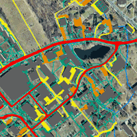
What you want is a separate data layer of your watershed/town that shows impervious cover. This will allow you to summarize the amount, keep track of any changes (additions, removals, disconnections) from that baseline, and in general get a feel for where the best opportunities might be. During this step it is useful, but not absolutely necessary, to categorize the IC by major type (roof road, parking lot, driveway, sidewalk, other); this information will be helpful later as you contemplate solutions.
If your IC-TMDL is based on recent, highly accurate data, then you should be able to obtain this information from the state agency issuing the regulation. However, in many cases the regulation may be based on modeling or other methods that provide a reasonable estimate of the overall picture, but do not provide the geographic specificity and accuracy that you need to craft a site-level response plan. In this case, you must develop your own data and maps from publicly available high resolution imagery like the CT-ECO website, GoogleEarth® and GoogleMaps.® The first video below uses our Eagleville Brook project to show what a digitized impervious cover dataset looks like. The second video shows you how to access the new 2012 high resolution aerial imagery from CT ECO.
The Eagleville Brook IC Data Video (Map IC video)
CT ECO Imagery video
The Geospatial Training Program (GTP) provides technical education and training outside the traditional academic environment. The program's goal is to help municipal land use officials, staff and commission members understand and apply geospatial information technologies to help solve local land use problems and to develop environmentally sensitive land use plans. The program focuses on the use of geographic information systems (GIS), remote sensing (RS) and global positioning system (GPS) technology and online mapping and introduces new users to these technologies through hands-on training courses.


